
by REERA YOO
On Friday, Daum launched a map service that covers North Korea’s entire territory, becoming the first South Korean Internet portal to offer public access to North Korea’s geographical information.
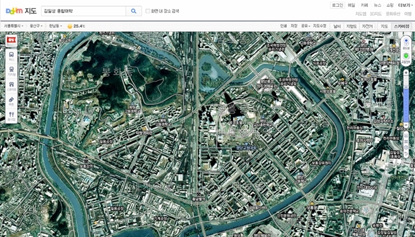
The map service shows all nine North Korean provinces and includes its administrative districts and their names as well as locations of mountains, roads, landmark buildings, and railroads. Users can now access the map for free through their personal computers and smartphones, both in satellite and electronic view, according to Daum.
 Downtown area of Pyongyang, as shown on Daum Maps on August 30.
The National Geographic Information Institute (NGII) had created the map on a scale of one to 25,000 and 50,000. Previously, they had only provided the information to state agencies that dealt with North Korean affairs until the Ministry of National Defense, Ministry of Unification, and the National Intelligence Service all agreed to opening the map to the public in March.
Since the geographic data was compiled between 2007 and 2009, the map is dated and the image resolution is not as sharp as Google Maps. However, Daum stated that its map depicts the most accurate and current information of North Korea.
“The date is a lot older than Google’s,” said Kim Chang Woo, a NGII researcher. “But the map covers all areas of the North while Google only provides a few big cities like Pyongyang and Sinuiju.”
While Daum updates their maps every year and has more current information with higher quality, the company has decided to only provide older maps of North Korea for national security reasons, reports Korea Joongang Daily.